

")


- Posts: 4
- Thank you received: 0
How to turn GSHSS off?
- Wesa
- Topic Author
- Offline
- New Member
-

Less
More
11 months 3 weeks ago #3230
by Wesa
How to turn GSHSS off? was created by Wesa
Hi! qtVlm documentation mentions on page 154:
Shapefiles can be used as barriers. For instance, if you do not want to use the imprecise gshhs coast lines from gshhs, you can specify in Charts configuration that you want to use coasts lines from vector charts, load a shapefile and indicate that you want to use it as a barrier. qtVlm will then stop using gshhs and will use the shapefile and eventually the vector charts if any for all coast’s detection functions.
I am able to load a shapefile via Charts > Shapefile and SHOM an mark it as a barrier, but I can't seem to figure out how to disable the GSHHS from qtVlm > Configuration. Any suggestions?
Help would be much appreciated!
Wesa")
Shapefiles can be used as barriers. For instance, if you do not want to use the imprecise gshhs coast lines from gshhs, you can specify in Charts configuration that you want to use coasts lines from vector charts, load a shapefile and indicate that you want to use it as a barrier. qtVlm will then stop using gshhs and will use the shapefile and eventually the vector charts if any for all coast’s detection functions.
I am able to load a shapefile via Charts > Shapefile and SHOM an mark it as a barrier, but I can't seem to figure out how to disable the GSHHS from qtVlm > Configuration. Any suggestions?
Help would be much appreciated!
Wesa
Please Log in or Create an account to join the conversation.
- maitai
- Offline
- Administrator
-

Less
More
- Posts: 1273
- Thank you received: 25
11 months 3 weeks ago #3231
by maitai
Replied by maitai on topic How to turn GSHSS off?
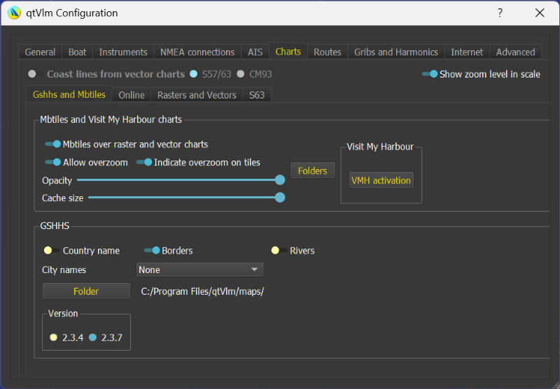
In vector charts parameters activate "Coast lines by Vector charts" and make sure you don't have any S57 where the barrier is
Please Log in or Create an account to join the conversation.
- Wesa
- Topic Author
- Offline
- New Member
-
Less
More
- Posts: 4
- Thank you received: 0
11 months 3 weeks ago #3232
by Wesa
Replied by Wesa on topic How to turn GSHSS off?
Thank you for the quick reply! The option "Coast lines from vector charts" seems to be grayed out. I haven't added any S57 files, working with a completely new install.
Please Log in or Create an account to join the conversation.
- maitai
- Offline
- Administrator
-
Less
More
- Posts: 1273
- Thank you received: 25
11 months 3 weeks ago #3233
by maitai
Replied by maitai on topic How to turn GSHSS off?
Just add one free chart from the US, using our NOAA chart downloader
Please Log in or Create an account to join the conversation.
- Wesa
- Topic Author
- Offline
- New Member
-
Less
More
- Posts: 4
- Thank you received: 0
11 months 3 weeks ago #3234
by Wesa
Replied by Wesa on topic How to turn GSHSS off?
That did the trick! Many thanks!!!
Please Log in or Create an account to join the conversation.
Time to create page: 0.126 seconds